How it works

One address. One read, every finding cited. Reweighted for your plan.

The same site means different things to a buyer, a builder, an investor or a developer. KRAYN keeps the facts the same and changes how they're read.

  1. Enter an addressanywhere in Australia
  2. Say what you are planningbuy, build, subdivide, invest
  3. KRAYN runs the checksevery applicable layer, at your boundary
  4. You get a verdictplain English — and where your plan moves a check, it names which one
  5. Optionally, add your documentsthe contract and disclosure pack, cross-checked (optional)
REAL REPORT · not a mockup
Loading live report…
Reading this site as
Verdict · judged for your job
Reading the site for this job…
Same address, same facts. Change the job and the read can move. See the full report →
How a report starts

Start with an address. Add a document if you have one.

There's one way in: an address. It produces the read. A document is an optional extra you can layer onto that same report, never a separate front door.

The entry

Enter an Australian address

This is how every report starts. KRAYN gathers the source-cited findings about the site (planning, hazards, land and title, site conditions, future land use), each cited in your report, and reads them for what you're doing.

Live now
Optional add-on · on your finished report

Add a document

Once your report is ready, you can optionally attach a contract of sale, a vendor's statement, or a planning report — from the document panel on the report itself. KRAYN audits its stated claims against the same government records the report reads, flagging where the document and the record don't line up. It reads even a scanned statement, and tells you plainly what it couldn't read. Not a second way in: an independent check layered onto your site read.

The audit checks a document's stated claims against source data and flags discrepancies. It doesn't verify the whole document is correct. A clean audit is not a clean document; we say what was checked.KRAYN doesn't store your document. The file is read in memory and discarded. The text we extract is sent to our AI provider to be read, and may be retained by them for up to 30 days. The audit result — what was found and what wasn't — is kept with your report so you can reopen it.

Formats
PDF, Word (.docx), text and CSV, up to 25 MB. Anything else is refused with a reason, not silently ignored.
What is audited
The property facts the document states — zoning, overlays, heritage, bushfire designation — each cross-checked against government data.
What we keep
The file is read in memory and discarded — never written to disk. The text we extract goes to our AI provider to be read, and may be retained by them for up to 30 days. What we keep is the audit RESULT: which claims were checked, which matched, and which could not be read.
Which states
What can be cross-checked varies by state, because the underlying data does. Your report states, for your state, what was and was not checked.
What it cannot settle
Covenants, owners-corporation matters, rates and building permits are outside the comparator. It is a claim-check, not a certification.
Live now
One engine, two controls

Two dials. The facts never move under either.

Your report isn't a fixed document. It's a live read you steer with two controls, and the facts never move under either.

The source-cited findings
  • Hazards & constraints
  • Land & title
  • Site conditionsLeads
  • Future land use
  • Evidence
Same facts, every time. Cited to source.
Viewing this site as…intent: what you're doing

The facts don't change, only which findings lead.

Reading styleregister: how it reads

The findings don't change, only the language.

Your readPlain · leads with Site conditions

Shallow rock or reactive clay can change the foundation system and the cost, something to price before you commit.

Clear language: what we found, and what to check before you commit.

Two dials: what you're doing, and how it reads. The source-cited findings underneath stay identical. You change the question, not the data.

Why there’s no photography in our 3D

We built the land itself.

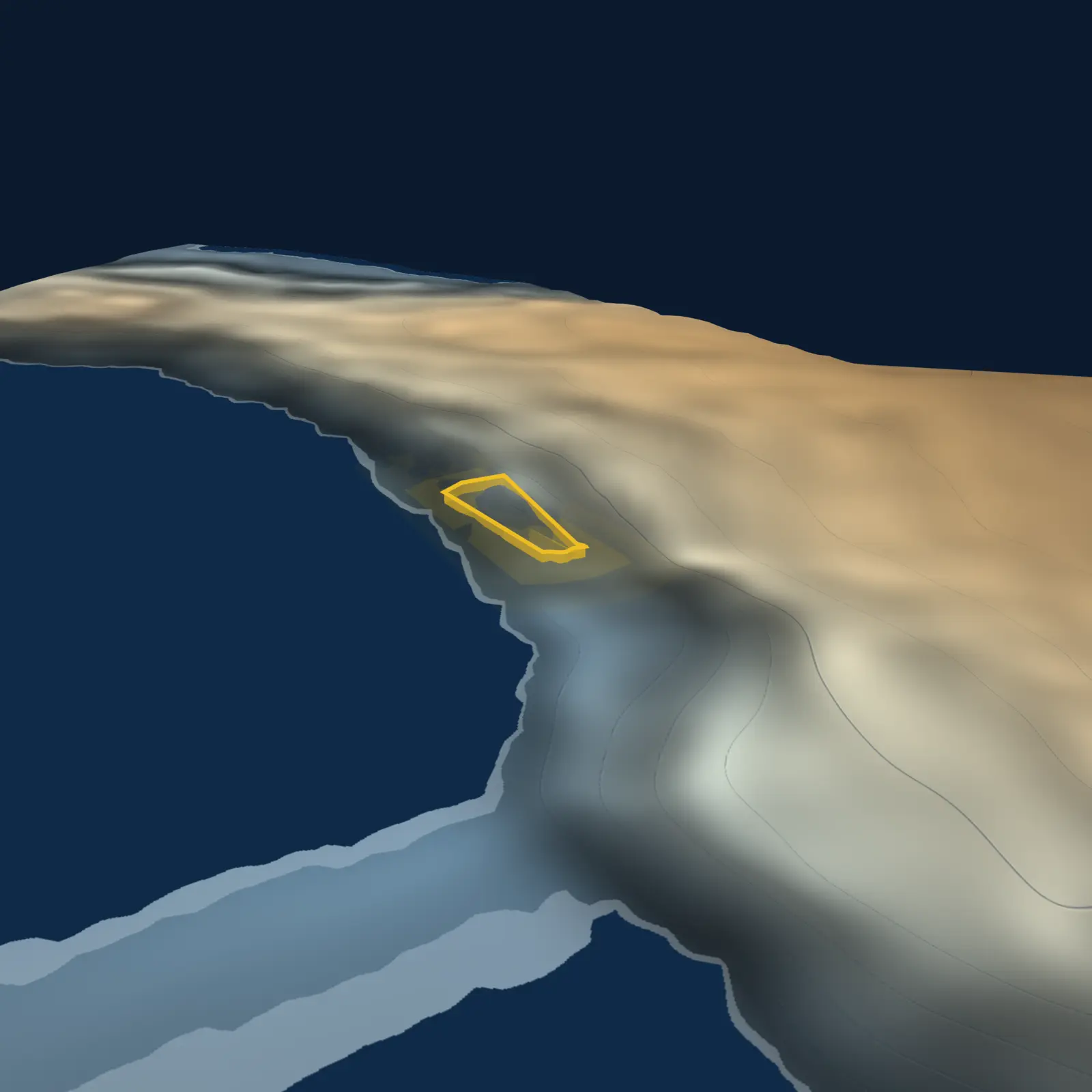
Every KRAYN report carries a 3D model of the site — not a photograph, not satellite imagery, not an artist’s impression. A measured rendition of the land, computed from the Commonwealth’s own elevation survey.

A KRAYN 3D terrain model of 8 Bay St, Greenwich NSW — a low frontal view of the escarpment dropping to the harbour, the parcel picked out mid-slope. A computed model, not a photograph.
TERRAIN
OVERLAND FLOW
HERITAGE
Live sample A model, not a photoGreenwich NSW · GA 5 m LiDAR · © Commonwealth of Australia · CC BY 4.0
How the model is made — the full methodologyWhy it exists, how it’s computed, what it refuses to show, and why it’s licence-clean.

Why it exists. A listing photo shows you what’s on the land. It cannot show you the land — and the land is where the hidden costs live. A 38-degree fall across a parcel disappears in a photograph; it commands the model. Slope, fall direction, where water goes when it rains, what winter light reaches the block — these shape footings, drainage, retaining walls and daylight, and none of them are visible in a photo. So we model the thing the costs come from.

How it’s made. The terrain is baked from Geoscience Australia’s 5-metre LiDAR elevation grid — public, measured, licensed for exactly this. Onto it we compute, never draw: relief shading and elevation tint from the measured heights; engraved contours; slope-darkening so steeper ground reads darker (and we say so on the model); the parcel boundary from real cadastral geometry; overland flow traced from the same elevation; sun positions computed astronomically for the site’s actual latitude — the winter shadow you see is the winter shadow the block gets. The grade figure on the model is the report’s own number, to the decimal. One source of truth, extended into three dimensions.

What it refuses to show. Buildings, fences and vegetation are not modelled — we’d rather show you nothing than show you a guess. The model never displays anything the report hasn’t assessed. And it’s stamped on every frame: a model, not a photo.

Why it’s ours. Because every pixel is computed from open government data, the model is licence-clean end to end — it appears in your PDF, works for any Australian address the elevation survey covers, and rents nothing from anyone. Property products either show you flat maps or someone else’s photography. We built the land.

Explore the model on our live Greenwich sample
WHEN TO RUN IT

An instant, honest read on any site. Before you commit.

Every site you commit to carries a recorded layer: overlays, corridors, boundaries, the plans already on file. KRAYN reads it instantly and honestly. Pick who you are, and see where that read fits your journey.

CHOOSE WHO YOU ARE — THE JOURNEY RE-READS FOR YOU

First-home buyer. One home to live in, first time, emotionally invested, deposit-stretched.

THE PURCHASE JOURNEY: THE COMMON TRACK
STAGE 01

Discovery

Weighing many properties

Walk away free, nothing committed

STAGE 02KRAYN SCREENS HERE

Shortlist

Narrowing to a few

Still cheap to drop one

STAGE 03KRAYN SCREENS HERE

Commit

Offer · contract · deposit

Deposit at risk; cooling-off is short and varies by state

STAGE 04

Diligence

Conveyancer engaged

A $900–$2,500 fee, spent on THIS one property

STAGE 05

Settle

Money changes hands

Irreversible

COMMITMENT COST RISES DOWN
ENTRY · SHORTLIST → COMMIT

KRAYN screens here: before you commit, the recorded picture against the brochure.

Does the recorded picture match the listing, before the deposit goes down?

The deposit and a short, state-varying cooling-off window are what you can lose. The screen lands just before them.

See it on a real report
WHAT THIS IS, AND ISN'T

KRAYN shows you where it sits and the question it answers at that stage.

It gives you a cited verdict on the site — never a score, and never a “buy / don't buy” call. What you do with the read is yours.

The honest read

How we stay honest.

Most of what a buyer sees about a site is supplied by the seller. KRAYN is the independent read, and the discipline behind it is the product:

Every finding is cited to its source.
Government and industry data, named, not our opinion.
Coverage is named.
We tell you what we checked and what we couldn't, because absence of a finding is not a clean bill of health.
A verdict is a read, not a clearance.
We tell you what to verify, never that a site is "safe" or "approved."
An unavailable check never reads as a clearance.
Where the public record can't establish something, the report says so — and names which check it was, rather than leaving a quiet gap you could mistake for a pass.
We surface, we don't predict.
We'll show you a forward factor (a planned precinct, a reserved corridor) as a fact to weigh and verify. We never tell you a site will become valuable, or get approved.
Nothing is invented.
Every read is judged from the verified data, not guesswork. If we don't have it, we say so.

The engine is KRAYN's own, built in-house, and built to be honest with you before you commit.

What's in a report

What it covers.

Every report reads the site across five areas, AU-wide, with each layer named and each cited to its source.

Coverage varies by state and layer. Victoria has the deepest planning detail. Every report names exactly what was checked and what wasn't, because what we didn't check matters as much as what we did.

See exactly what we check

See the engine read a real site.